Improve your travel game in the Costa del Sol using Google Maps and other apps

Improving our trips around the Costa del Sol using Google Maps and the apps available for transportation in the area is very easy. Google Maps – my all times favorite –, Consorcio Malaga for buses, and Renfe’s app for train timetables are free, user friendly and available both on computers and phones.
These powerful tools make planning trips, choosing where and how to go to places, checking if the places are walkable, and even seeing the places ahead a lot easier. You can plan before even arriving in the Costa del Sol.
You may be familiar with Google Maps – heck, I bet you are! – But there is a lot to this tool, and maybe some of it that you had not realized was there. I am sort of addicted to it, and I’ve seen how much it improved over the years.
Google Maps can help with travel almost anywhere; I’ll use examples from the Costa del Sol in this description, as I know what tools are available for this area (and if you thought all tools were available equally everywhere, you already learnt something new!)
The basics: find buses and trains to go around
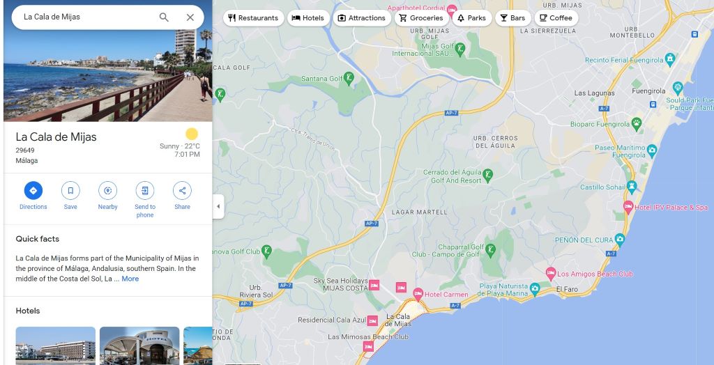
Suppose you want to go from your hotel to a place in another city of the Costa del Sol. How to find out the available ways to get there? With Google Maps! I’ll give an example here from Fuengirola (city center) to La Cala de Mijas.
First, open Google Maps and choose your destination (in our example, La Cala de Mijas):
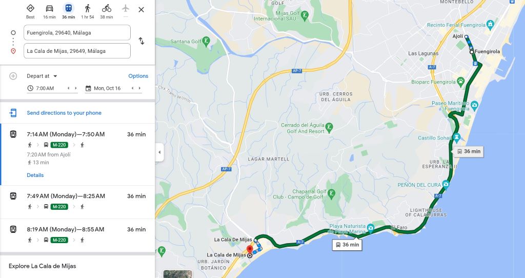
Then click Directions, the button shown in blue above. A new page will open, where you can write your departing point – in our example, Fuengirola:
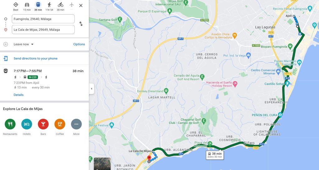
Voilá, Google will show you the available buses and times to do this route. If you click the arrow besides ‘Leave now’, you can change the date and time of your departure. Clicking in options will allow for some customization, such as wheelchair accessible or less walking. 😉
Consorcio Malaga
If you want to double check to make sure this bus is really available on the time shown in Google, open the app (or page) of Consorcio Malaga, choose the bus line suggested (M-220 in our example) and check their timetable.
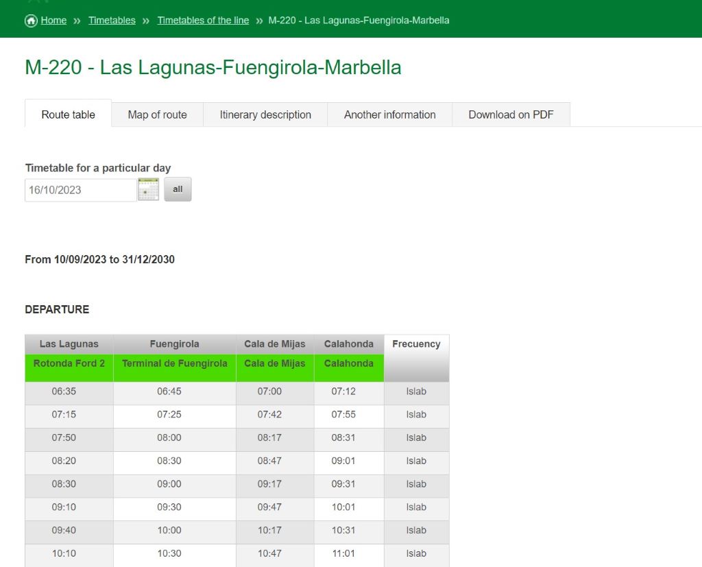
Note that the bus timetable does not show the time the bus will be at each of the stops of its route, just the main ones. The stop Google suggests us to depart from in our example (Ajolí) is not in the timetable, but Terminal de Fuengirola, a bit ahead, is. The bus would be there at 7:25; so, it is reasonable to accept that it would be at around 7:20 in the previous station. It worked!
Taxis or uber: checking uber prices
Good. It also shows that it would take about 36 minutes to do this trip by bus, but only 16 minutes by car. Is it worth taking the bus or would it be better to take an uber or a taxi? Well, it depends on the price of an Uber ride, and on how many people are going together. Taxis and Ubers have similar prices (from the comparisons I did, at least). But how to know what price that would be? Simple.
The important thing is that you know that you can open the Uber app and choose departure and destination points regardless of where you are! This means that you can check ahead how much it would cost to go by Uber to anywhere and from anywhere. Just don’t order the Uber yet. Of course, time affects both taxi and Uber prices, so checking ahead is a way to give you a price reference, not a definitive answer.
Related post:
Transportation in the Costa del Sol
Trains
Between buses and trains, I choose the train anytime I can. They are faster and more reliable – I’ve been waiting for buses that didn’t come quite a few times – but the train appears everytime. You can download the app of Renfe Cercanías (or check their page) for timetables and lines. They are shown on Google Maps’ routes too.
Related posts:
Free train tickets in the Costa del Sol
Train Stations in Malaga
Train Stations in Torremolinos
Train Stations in Benalmadena
Train Stations in Fuengirola
Now that is the basics. Let’s move on to more advanced stuff:
Plan trips with several stops with Google Maps
I used this feature of adding several destination points when planning the route I’d follow from Málaga Centro Alameda, on Train stations in Málaga; I found it really useful, because I could combine visits to several interesting spots in about one hour walk. That in itself is interesting: if you know how long you want to spend outside, you can plan ahead a route that fits your time.
For this post, I did a similar route example in Benalmadena:
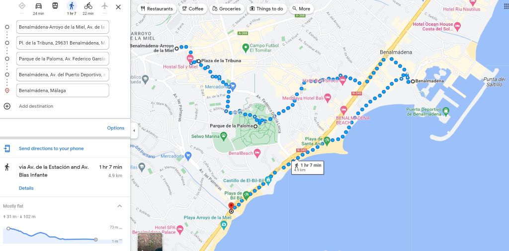
This route – described on the left of the image – goes from the train station to Fountain Square (official name: Plaza de la Tribuna) through Av. Blas Infante, then to La Paloma Park, from there to the Marina, seeing the city from the inside, and closes with a walk in the promenade, passing in front of Playa de Santa Ana and by the Bil-Bil Castle.
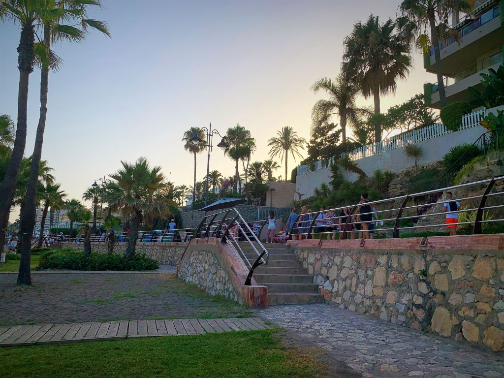
A nice route that can be done in a bit more than one hour, but that deserves at least three, with stops for tapas, drinks, pictures and maybe even a dip in the sea. 😉
Pro tip: you can add places by simply clicking on the map as well as by the name. Check ahead the names of the places you would like to visit, look at their locations on Google Maps and group then by proximity, so you can visit several nearby places in a day.
The only negative of this Google planning is that you can’t mix means of transportation. You can’t tell google maps that you intend to go from point A to B walking and from B to C by bus, for instance. On the example above I’d like to add a final trip from the beach back to the train station by bus, but it would only show the walking route; changing to bus would change all other routes, causing a mess.
Check the inclination between places
Whenever you choose walking as your means of transportation, Google Maps show the different heights of the chosen location(s). It works for both single or multiple destinations (see the picture of the route in Benalmadena), and if you follow the inclination with the mouse (no clicks needed), it will show where on the route it goes up and down.
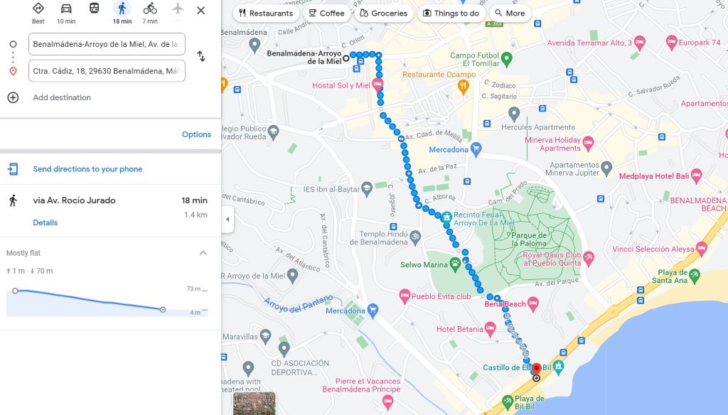
It says this walk from the train station of Benalmadena – Arroyo de la Miel to the beach is mostly flat in the sense that this route does not go up and down repeatedly; but the way back is a 70m uphill climb that does not feel flat at all!!!
Use this information to choose your means of transportation accordingly. 😉 I plan my trips downhill walking, uphill with either buses or ubers. Planning for inclination adds happiness to any trip!
Related post:
How hilly is the area
Save the places you want to visit
On the left side of Google Maps there is an icon called ‘Saved’. You can add everything you want to visit there, and it will show you their locations on the map (as long as they have been added to Google Maps; if not, you’ll need to add the address).
This way you can go preparing the places you want to visit long before you arrive – restaurants, beaches, squares; it helps to plan the routes as well!
See places in 3D with Google Maps
Have you been flying around on Google Maps lately? When I started to check the Costa del Sol using Google Maps, there was no 3D available for the area. I was trying to find Torremolinos elevators for quite a while!!! Now the whole Costa is there, ready to be flown anytime we feel like. How? Easily! I did a video; comments and explanations below:
Make sure you are using Google Maps on satellite view when you want to see the 3D. You do that by pressing the square on the bottom left of your screen. Choose satelite or “more”, if satellite is not one of the options that appear.
Next, you’ll need to make sure “globe view” is selected (on “more”, on the same bottom left square). This is a recent update; it wasn’t needed when I did the video.
Once you are on satellite + globe view, press shift and the left mouse button. Keeping both pressed, move the mouse from the bottom of the screen to the upper side of the screen. We are in 3D now. Release both buttons.
If you want to move, press the left mouse button and pull or push towards where you want to go. If you want to see around somewhere, as I did around the Casa de los Navajas (in Torremolinos) in the beginning of the video, press shift and the left button of the mouse again; release the shift to slide.
You can switch between 3D, 2D or street views as much as you would like. From 3D or 2D to street view, use the little yellow guy on the bottom right; to go back to 3D, press X on the top right. If you start to feel dizzy, it is usually time to stop!!!
Conclusion
Google Maps and the other apps available in the Costa del Sol make planning a fun part of the trip. The best part is the anticipation of what is to come, isn’t it? We kind of start feeling as if we are already where we want to be when we can see and plan all the joy we’ll have. So enjoy the preparation and never feel like you are lost anywhere (that has internet. Though you can download the maps to see them offline as well). Best travels!


You may also like...

7 Great Places for Culture in Benalmadena
Culture in Benalmadena – Imagine you are on a beach in Benalmadena when you suddenly spot a body on the... Continue reading

Bus and train cards in the Costa del Sol – (almost) all you need to know
The bus and train cards available in the Costa del Sol are very popular and extremely useful because they give... Continue reading

One thing to take in consideration when choosing where in Spain to relocate is how hilly is the area you... Continue reading

The 9 Benalmadenas – all about the neighborhoods of Benalmadena
Neighborhoods of Benalmadena – If you are just starting to fall in love with Benalmadena, knowing each of its neighborhoods is... Continue reading

Butterfly Park and Stupa of Enlightenment
Benalmadena’s Butterfly Park and Stupa of Enlightenment are two landmarks of the town. They are located very close to each... Continue reading

There are only two train stations in Benalmadena: one in Arroyo de la Miel; the other in Torremuelle. Continue reading